A special training supplement illustrated with actual weather charts, tables, pictures and graphics to highlight the pilot-in-command's planning and decision-making process with respect to operating under IFR when in-flight airframe icing conditions must be considered.
For the purposes of this example scenario, we shall consider an imaginary Part 135 carrier -- Austin's Air Service, LLC. (This is the same imaginary carrier I use throughout my AVEG series.) Suppose AAS Dispatch calls you up at home and offers you a "special" -- a one-time assignment not associated with a regular contract run. (AAS is an on-demand / unscheduled operator, so this sort of thing is not uncommon.) It would entail flying IFR from Orlando (ORL) to Gainesville (GNV) at 4,000 feet with a single 30-pound document pouch filled with proof-of-deposit (P.O.D.) work for one of our bank customers. The date is Saturday, January 9th, 2010.
As you get to the airport, it's rainy, misty, cloudy and quite chilly.
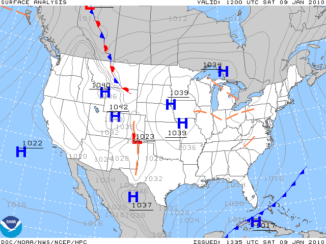
A cold front has just pushed through the peninsula, leaving abnormally low temperatures in its wake:
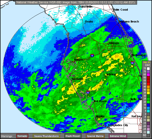
Moreover, bands of light but steady rain are still falling across the central part of the state, with isolated pockets of heavier precipitation to the south of Orlando:
Obviously, ground icing conditions do not exist. In-flight ice is a possibility, however, so you have to answer six questions:
The current METAR says:
KORL 091453Z 33006KT 10SM -RA SCT036 BKN040 02/M06 A3023
It's only two degrees (Celsius) above freezing at ground level. The dew point is minus six, giving a temperature-dew point spread of eight degrees. Assuming a standard approximate lapse rate of about 2 degrees per thousand feet, we would assume that the ceiling (defined, as you recall, as the lowest broken or overcast layer) would be found at about 4,000 feet, and guess what? Sure enough -- it is.
We would also assume based on this same rule-of-thumb math that the freezing level is at about one thousand feet -- bearing in mind that there is often an inversion layer in cold weather, meaning that the real freezing layer may be higher than that.
Since it's currently raining, if the freezing level really is 1,000 feet, it would be necessary to take an ice-approved airplane.
Why is there often an inversion layer in cold weather, especially in the morning? Well, the answer is quite simple: the planet Earth radiates heat away into space overnight, becoming very cold, while the air above it (which does not radiate heat) remains at a relatively constant temperature. The part of the atmosphere immediately adjacent to the ground is cooled by its proximity to the surface. This is why, when you first take off in the wintertime, you often climb into a slightly warmer outside air temperature zone. This effect is even more pronounced after clear nights, when terrestrial radiation is at its maximum.
You check the Inflight Aviation Weather Advisories . . .
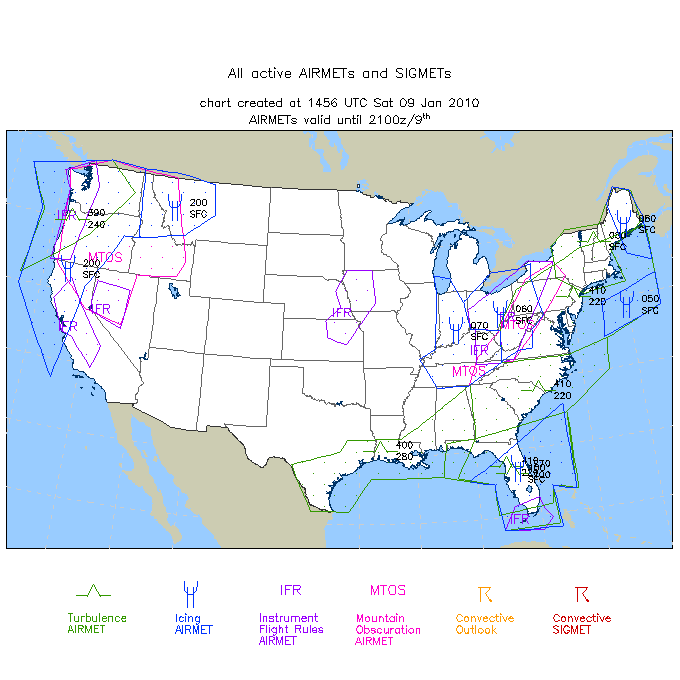
Wow, lots of AIRMETs and SIGMETs this morning, aren't there? Let's just concentrate on the ice issue for right now. Is there an icing AIRMET for the laterally delineated geographic area in which our flight is supposed to take place? Yes, there clearly and absolutely is:
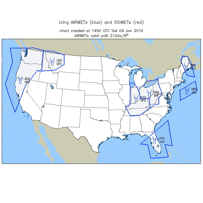
Notice the vertical limits of that AIRMET, however, before you let yourself get too worried. This is actually encouraging -- it strongly suggests a relatively high freezing level. We like high freezing levels.
|
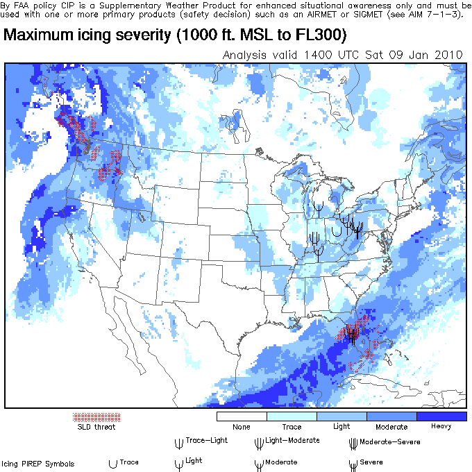
This graphic is particularly alarming: not only does it show the potential for moderate to heavy ice in our area, it even warns of the possibility of SLD (supercooled large droplets). Despite the fact that there is no SIGMET for severe ice published, SLD should always be considered a very serious threat.
This is where an inexperienced (or excessively nervous) pilot might completely freak out. "Heavy icing conditions," he exclaims in irrational terror, looking at the chart above. "I can't go! It's too dangerous! I have to cancel the flight! Aaaiiiggghhh!" Then he would run and hide, curled up shivering in a fetal position inside the station box.
Well, maybe not -- but he might announce to Dispatch that he can't go because he doesn't think it's safe or legal.
But you're much smarter than that. You are going to dig deeper to get the whole story. You are going to pull up all the raw data to develop a fuller, more complete mental picture of the overall weather situation and employ your extensive, detailed knowledge of meteorology -- along with your professional judgment and aeronautical experience -- to make a wise, prudent, sensible decision based on the true facts and practical circumstances.
The next place you look is the Winds and Temperatures Aloft Forecast -- a veritable gold mine of handy and useful information:
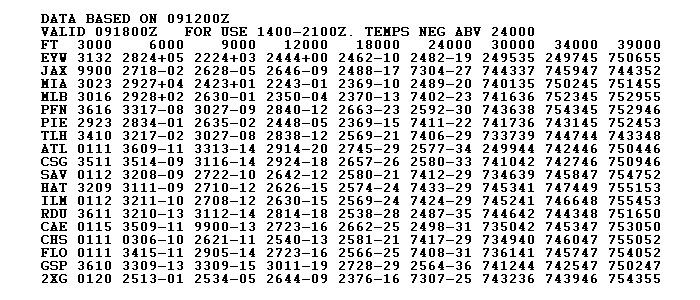
A few quick explanatory notes here:
DATA BASED ON 091200Z
(This means that the numbers below are based on actual atmospheric sounding observations taken at 0912 Zulu or 1412 Eastern.)
VALID 091800Z FOR USE 1400-2100Z. TEMPS NEG ABV 24000
(Note that all temperatures above 24,000 feet are negative. The minus sign is not used. The outside air temperature at 30,000 feet over Key West, for example, is negative 35 degrees Celsius. The wind is blowing from 240 degrees at 95 knots there.)
JAX 9900
(When the forecast wind speed is less than 5 knots, the code group of 9900 is used -- meaning light and variable.)
What you're looking for right now is further confirmation of your theory that due to a low-level inversion the real freezing level is actually significantly higher than 1,000 feet along a line between ORL and GNV. The temperatures at 6,000 feet for Melbourne (MLB) and Miami (MIA) are above freezing -- an excellent sign! -- and looking in the direction you're going, north, you see that in both Tallahassee (TLH) and Jacksonville (JAX) the forecasters are calling for two degrees below freezing at 6,000. So, still assuming a standard lapse rate, an actual freezling level at or above the range of 4,000-5,000 feet sounds quite reasonable between Orlando and Gainesville . . . for the moment. But you're not done yet.
Next, you consult the Area Forecast to get a general sense of the large-scale, widespread weather conditions and trends:
Miami Area Forecast (FA)
Forecast updated: 09:31 UTC
FAUS42 KKCI 090945
FA2W
MIAC FA 090945
SYNOPSIS AND VFR CLDS/WX
SYNOPSIS VALID UNTIL 100400
CLDS/WX VALID UNTIL 092200...OTLK VALID 092200-100400
NC SC GA FL AND CSTL WTRS E OF 85W
.
SEE AIRMET SIERRA FOR IFR CONDS AND MTN OBSCN.
TS IMPLY SEV OR GTR TURB SEV ICE LLWS AND IFR CONDS.
NON MSL HGTS DENOTED BY AGL OR CIG.
.
SYNOPSIS...CDFNT OVR XTRM SRN FL PEN MOVING SWD. 22Z CDFNT S OF
SRN FL PEN. 04Z HI PRES SLOLY BLDG OVR REGION.
.
NC
MTNS...SCT040-050. OCNL SCT CI. OTLK...VFR.
PIEDMONT...SCT-BKN CI. OTLK...VFR.
CSTL PLAINS...BKN-OVC CI. BECMG 1617 SCT CI. OTLK...VFR.
.
SC
MTNS...BKN CI. BECMG 1719 SCT040-050. OTLK...VFR.
PIEDMONT...BKN CI. BECMG 1719 SCT CI. OTLK...VFR.
CSTL PLAINS...BKN CI. BECMG 1719 SCT CI. OTLK...VFR.
.
GA
NRN...SCT-BKN CI. 15Z SCT CI. OTLK...VFR.
SWRN...BKN CI. 15Z SCT-BKN CI. OTLK...VFR.
SERN...BKN130. TOPS FL250. 15Z SCT-BKN CI. 17Z SCT CI.
OTLK...VFR.
.
FL
PNHDL...BKN150. TOPS FL250. 15Z SCT-BKN CI. OTLK...VFR.
NRN PEN...BKN120. TOPS FL250. 12Z BKN050 LYRD FL250. ISOL -RA.
BECMG 1718 SCT CI. OTLK...VFR.
CNTRL PEN...BKN080. TOPS FL250. ISOL -RA. BECMG 1314 SCT030
BKN070 LYRD FL250. ISOL -RA. 18Z SCT035 BKN130. TOPS FL250.
21Z SCT040 SCT CI. OTLK...VFR.
SRN PEN...BKN-OVC030. TOPS 120. BECMG 1314 SCT010 BKN020. TOPS
FL250. ISOL -RA. 20Z SCT025 BKN080. TOPS FL250. OTLK...VFR.
.
ATLC CSTL WTRS
N OF SAV...SCT030 BKN-OVC CI. WND NW 20G30KT. BECMG 1821 SCT030
SCT CI. ISOL TSRA. CB TOPS FL350. WND NW G25KT. OTLK...VFR
TSRA WND.
S OF SAV...SCT025 BKN-OVC100. TOPS FL250. WND NW G25KT. BECMG
1215 OVC015. TOPS FL250. ISOL TSRA. CB TOPS FL400. WND G25KT.
OTLK...MVFR CIG TSRA WND BR 23Z VFR TSRA WND.
GULF CSTL WTRS E OF 85W
N OF SRQ...SCT025 BKN-OVC080. TOPS FL250. WND N 20G30KT. BECMG
1215 SCT015 BKN CI. WND N G25KT. 18Z SCT030 SCT CI.
OTLK...VFR.
S OF SRQ...OVC015. TOPS FL250. WND N G25KT. BECMG 1215 SCT015
BKN-OVC100. TOPS FL240. WND NE G25KT. 21Z SCT020 BKN-OVC150.
TOPS FL250. WND NW G25KT. OTLK...VFR.
Notice that all over Florida, the rain is supposed to be tapering off and the clouds are supposed to be breaking up, leaving clear skies north of Sarasota and a very high broken or overcast ceiling down south. The outlook is VFR across the board.
The latest METAR from Gainesville says:
KGNV 091453Z 36006KT 10SM CLR 02/M09 A3027 RMK AO2 SLP251 T10061094 52016
The plus-two reported surface temp at Gainesville -- the same as Orlando -- continues to suggest a low freezing level. More importantly, however, notice that the sky is unobscured and there is no precipitation. Therefore, there are no actual icing conditions. It's just clear, cold air.
In order to have airframe ice, two ingredients must be present:
Moreover, the most recently published TAF for Gainesville says:
KGNV 091121Z 0912/1012 33010KT P6SM BKN050 OVC100
XXXXXFM091500 33011KT P6SM BKN100 OVC250
XXXXXFM091700 33011G17KT P6SM BKN250
XXXXXFM092300 31007KT P6SM SKC
The ceiling (defined, again, as the lowest broken or overcast layer) is never expected to fall below 5,000 feet. It's expected to rise to 10,000 feet and then 25,000 feet before becoming completely clear after 2300 Z (1800 Eastern or 6 P.M.) Even with a freezing level all the way down at the surface, there would be no threat of ice. This is great news.
Click HERE to return to the "Flying" index page.